| The McDonald's Track Plaque near the roundabout at the McDonald's Track and Westernport Road intersection, Lang Lang. |
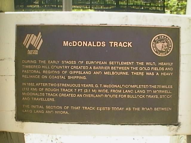 |
| The McDonald's Track Plaque near the roundabout at the McDonald's Track and Westernport Road intersection, Lang Lang. |
|
In 1860 Mr G. T. McDonald started constructing a track, that still bears his name, starting from Tobinyallock (now Lang Lang). The plan of his survey was endorsed: "Plan of trial survey from Melbourne to Gippsland, via Cranbourne and Tobinyallock. Diverting from the Lower Gippsland Road at Yallock Bridge (Lang Lang River bridge) and joining the Upper road at Morwell Bridge." This was the biggest piece of road construction ever done in South Gippsland. It ran easterly and north-easterly from Tobinyallock to Morwell, a distance of about 112 Km (70 miles) and for most of the way, through the heart of the big scrub country. The track was only 2.1 metre (7 foot) wide.
The road was intended for a better stock route from Sale to Melbourne, but was abandoned as there was no permanent water on it, although it ran through some exceptionally wet country. The reason for this was for most of the way it ran along the top of the dividing range, which falls away sharply in places.
After completing the track in 1862, it remained idle and unused for 12-13 years. When the first pioneers came, the track was entirely overgrown and very difficult to trace. So much so that some of the blocks were surveyed right across it, the land surveyors not noticing it at the time. After being run again, it became the base line for the survey of many thousands of acres and as the settlers came in, they kept opening up the old "7-foot" track further and further east.
The first encounter the pioneers had to traverse was the sand hills at Lang Lang East. After leaving the Lower Gippsland Road (now South Gippsland Highway) at Lang Lang, they headed east for about 10 Km past the Cherry Tree rises and came to Tinpot Hill (now just before Forest Drive at the road cut-out). It was steep, 1 in 4, sandy with no solid bottom and almost impassable during winter.
Mr G. T. McDonald was a native of Dumfries, Scotland. He arrived in Victoria in 1853 and worked as a surveyor. In 1870 he married a daughter of the Hon. W. F. Mitchell and 8 years later went to Queensland, entering the survey department there. He also took up land in that state, where he resided with his family for 37 years. He died at Wynnum, a Brisbane suburb, at the age of 80 years.
For further information refer to the book "The Land of the Lyre Bird", A Story of Early Settlement in the Great Forest of South Gippsland. Published in 1966 by The Shire of Kurumburra for the South Gippsland Development League.